


- Operating instruments: AIRS, AMSU, CERES, and MODIS.
- Current life expectancy: Aqua has a strong chance of operating successfully into September 2026.
- Current systems issues: None.
- Data access: The processed Aqua data are available through several NASA data centers identified on the images and data page.
- The Aqua data are also transmitted via direct broadcast, from which they can be processed for real-time applications using technologies and algorithms available from the NASA Direct Readout Laboratory (DRL).
- Greater detail on the status of the Aqua spacecraft, instruments, and other aspects of the mission are presented in a PDF Aqua Status file, updated monthly.
- View past Aqua Status files here.
Aqua Earth-Observing Satellite Mission
Aqua is currently in 'free-drift'!
What is its past, current and future altitude and equator crossing time?
Drag your cursor over the graph below to find out!
Due to fuel limitations, Aqua completed the last of its drag makeup maneuvers in December 2021 and is now in a free-drift mode, slowly descending below the A-Train and drifting to later equatorial crossing times, and lower altitudes. In Fall of 2026, passivation of the aircraft will begin.
Aqua data users have expressed the need for weekly updates on Aqua’s equator crossing time (in Mean Local Time [MLT]), as well as orbital altitude. Starting this month, we’ll be adding this information to the Aqua homepage and updating it weekly using data provided by the Operations Team. Move your cursor over the chart below to view both Aqua’s Mean Local Equator Crossing Time in UTC (dark black line) and orbital altitude (grey line) for each month through 2026.
Latest News from the Aqua Mission
View Past News Highlights here
May 3, 2024
What Happens When NASA Loses Eyes on Earth? We’re About to Find Out.
A New York Times article came out today that highlights the importance of climate data record continuity and just how fortunate we have been over the past 20 years having Terra, Aqua and Aura satelites to monitor the earth.
"In a way, it’s a credit to NASA that Terra, Aqua and Aura have lasted as long as they have, scientists said. “Through a mix of excellent engineering and a tremendous amount of luck, we’ve had these for 20 years now,” said Waleed Abdalati, a former NASA chief scientist now at the University of Colorado Boulder."
 "Since its launch more than two decades ago, the Aqua mission has delivered observations essential to improving our understanding of global dynamics and processes occurring on the land and cryosphere, the oceans, and the atmosphere. Furthermore, the Aqua mission has addressed topics of national priority such as weather forecasting, homeland security and defense, and natural resource management [...] Aqua is one of the most highly successful Earth observing satellites ever to have orbited our planet [...] As the Aqua satellite celebrates its 20th year in space, its contributions continue to advance our knowledge of Earth's systems for the benefit of humanity.”
From the citation of the USGS Pecora 2022 Group Award to Aqua.

Aqua, Latin for water, is a NASA Earth Science satellite mission named for the large amount of information that the mission is collecting about the Earth's water cycle, including evaporation from the oceans, water vapor in the atmosphere, clouds,precipitation, soil moisture, sea ice, land ice, and snow cover on the land and ice. Additional variables also being measured by Aqua include radiative energy fluxes, aerosols, vegetation cover on the land, phytoplankton and dissolved organic matter in the oceans, and air, land, and water temperatures.
The Aqua mission is a part of the NASA-centered international Earth Observing System (EOS). Aqua was formerly named EOS PM, signifying its afternoon equatorial crossing time. A timeline of Aqua on-orbit progress through the initial 120 day check-out period can be found here.
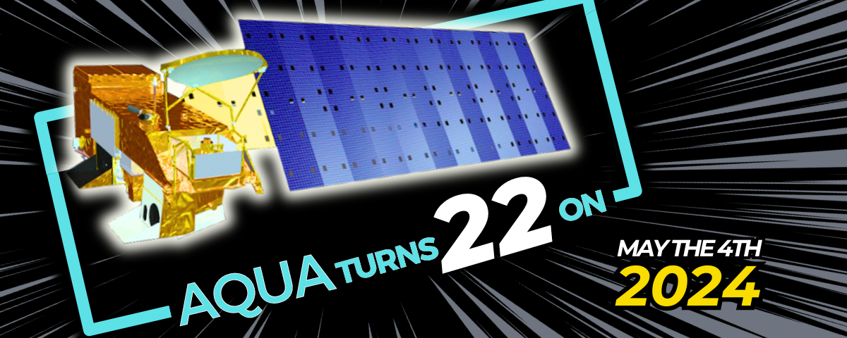
Aqua was launched on May 4, 2002, and has six Earth-observing instruments on board, collecting a variety of global data sets. Aqua was originally developed for a six-year design life but has now far exceeded that original goal.
It continues collecting and transmitting high-quality data from four of its six instruments:
Atmospheric Infrared Sounder (AIRS),
Advanced Microwave Sounding Unit (AMSU),
Clouds and the Earth’s Radiant Energy System (CERES),
Moderate Resolution Imaging Spectroradiometer (MODIS),
Advanced Microwave Scanning Radiometer for EOS (AMSR-E), suffered a major anomaly in October 2011 and ceased its high-quality data transmission at that time. Later the instrument was turned back on, and it transmitted reduced quality data important for intercalibration purposes before being powered off in March 2016.
Humidity Sounder for Brazil (HSB), collected approximately nine months of high quality data but failed in February 2003.
Aqua was the first member launched of a group of satellites termed the Afternoon Constellation, or sometimes the A-Train.
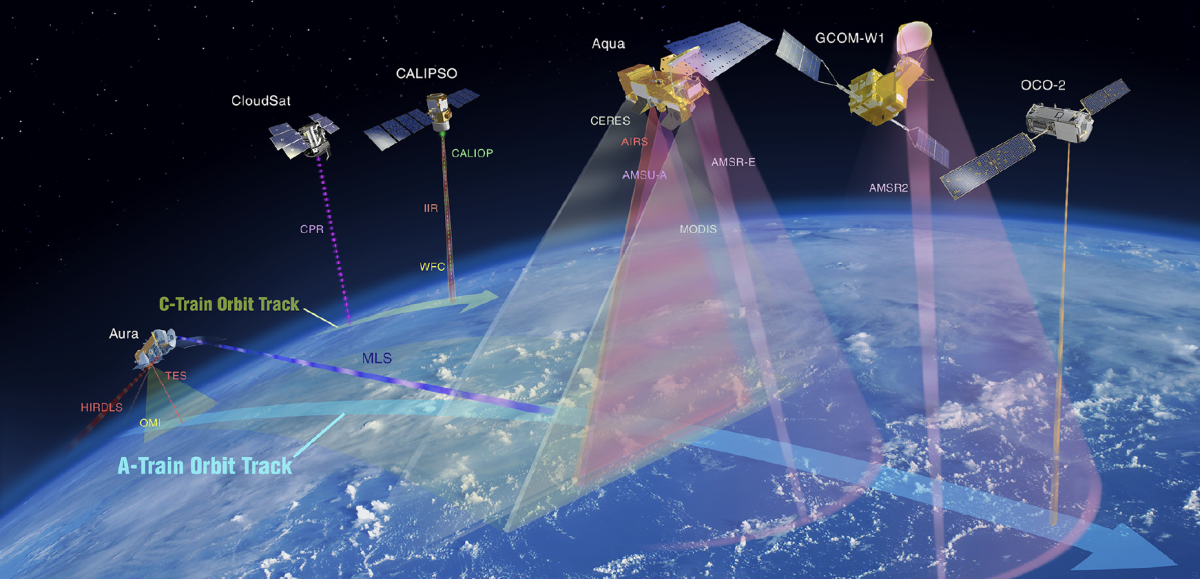
1.) Aqua, launched in May 2002
2.) Aura, launched in July 2004
3.) PARASOL, launched in December 2004 and completed its mission and exited the A-Train in December 2013.
4. & 5.) CloudSat and CALIPSO, launched in May 2006, and
6.) GCOM-W1, launched in May 2012
7.) OCO-2, launched in July 2014
When OCO-2 was launched, it the A-Train, followed by GCOM-W1, Aqua, CALIPSO, CloudSat, and Aura. By early 2022, CloudSat, CALIPSO, and Aqua had all exited the A-Train. Due to fuel limitations, Aqua completed the last of its drag makeup maneuvers in December 2021 and is now in a free-drift mode, slowly descending below the A-Train and drifting to later equatorial crossing times.
Recent Imagery Incorporating Aqua Data
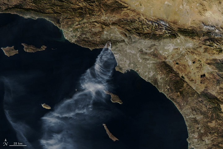
Smoke Streams from Palisades and Eaton Fires
Published on Monday January 13, 2025
Aqua Image Highlight
Aqua Status
Aqua Video Podcast Series
A series of five video podcasts (i.e., vodcasts) have been produced by NASA Goddard TV in conjunction with Aqua mission personnel.
- Vodcast 1, Introducing the Aqua Mission, viewable at the NASA Goddard YouTube channel and NASA Scientific Visualization Studio
- Vodcast 2, Aqua AIRS: Visions of Weather and Climate, viewable at the NASA Goddard YouTube channel and NASA Scientific Visualization Studio
- Vodcast 3, Aqua AMSR-E: Scanning Earth's Water Cycle, viewable at the NASA Goddard YouTube channel and NASA Scientific Visualization Studio
- Vodcast 4, Aqua MODIS: Science and Beauty, viewable at the NASA Goddard YouTube channel and NASA Scientific Visualization Studio
- Vodcast 5, Aqua CERES: Tracking Earth's Heat Balance, viewable at the NASA Goddard YouTube channel and NASA Scientific Visualization Studio
Aqua Science of the Month
November 2024
The fastest-growing and most destructive fires in the US (2001 to 2020)
Jennifer K. Balch et al., The fastest-growing and most destructive fires in the US (2001 to 2020).Science386,425-431(2024).DOI:10.1126/science.adk5737
"The most destructive and deadly wildfires in US history were also fast. Using satellite data, we analyzed the daily growth rates of more than 60,000 fires from 2001 to 2020 across the contiguous US. Nearly half of the ecoregions experienced destructive fast fires that grew more than 1620 hectares in 1 day. These fires accounted for 78% of structures destroyed and 61% of suppression costs ($18.9 billion). From 2001 to 2020, the average peak daily growth rate for these fires more than doubled (+249% relative to 2001) in the Western US. Nearly 3 million structures were within 4 kilometers of a fast fire during this period across the US. Given recent devastating wildfires, understanding fast fires is crucial for improving firefighting strategies and community preparedness."
MODIS data, specifically the Burned Area Product was used in this study.

FIgure: Temporal trends in maximum annual fire growth on a given day for events longer than 4 days per Environmental Protection Agency (EPA) ecoregion level IV from 2001 to 2020.
Statistically significant positive and negative regression coefficients (P < 0.05) are depicted in warm and cold colors, respectively. Regression coefficients that were not statistically significant from zero (i.e., no significant trend) are shown in white. Ecoregions without sufficient data for the analysis are indicated in gray.
See older science highlights here.